New Trail to Connect Cleveland West Side Neighborhoods to Downtown
LOCAL NEWS: New Trail to Help Connect Cleveland West Side Neighborhoods to Downtown


Source: Yuanshuai Si / Getty
CLEVELAND – Inside one of the oldest beer garden buildings in Cleveland, Forest City Brewery founder Jay Demagall says his two-year-old business is a “neighborhood brewery.”
“A lot of our customers will ride their bike in, they’ll walk to the brewery,” said Demagall, pointing out that the West 25th RTA Red Line stop isn’t far away.
He says the roughly two-mile Red Line to Greenway plan could only help bring more people to his door. The idea for the path came together with the help of Lennie Stover and his fellow Rotarians, who volunteered their time to maintain the stretch of land near the West 25th stop for decades.

A map from Cleveland Metroparks shows the path the Red Line Greenway would take from near the river to Zone Recreation Center.
They brought together groups like the Greater Cleveland Regional Transit Authority (RTA), who owns the property, N.O.A.C.A., and Metroparks to make the project happen.
“It would be a multipurpose trail,” said Stover. “It’s one of the nice things, it’s not just a bike trail.”
“Be it a railroad, be it a roadway, Interstate 90, the rail line along the lakefront, all those are barriers that we now need to overcome to reconnect people,” said Cleveland Metroparks Chief Planning and Design Officer Sean McDermott.
McDermott says a big part of the reason the project has already gotten millions of dollars in federal grants is because it reconnects parts of Cleveland that have become disconnected over time.
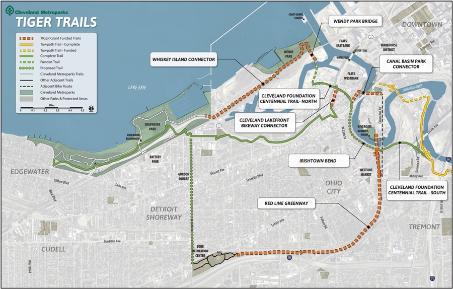
A full map shows how TIGER (Transportation Investment Generating Economic Recovery) grants have helped connect different Cleveland neighborhoods by trailways.
To do it, Stover says he envisions a “linear park.”
While traditional parks are in the middle of cities and are closed in by streets or fences, “a linear park connects people and encourages you to explore,” said Stover.
McDermott says that fits right in with the Metroparks main goals.
To do it, the trail will run from the Zone Recreation Center on Lorain and West 65th Street to the Cuyahoga River, near Hoopples at 1930 Columbus Road.
That two-mile stretch would connect the following communities:
- Downtown Cleveland
- Warehouse District
- The Flats
- Duck Island
- Tremont
- Ohio City
- Clark-Fulton
- Detroit Shoreway
- The Stockyards
But, the trail might not look exactly how Stover envisions it right now.
In August 2018, RTA took the first step towards potential development by publishing a Request for Qualifications for developers.
In a statement, RTA says:
The Greater Cleveland Regional Transit Authority (RTA) is seeking to develop a key parcel of land located along the RTA’s Red Line, with frontage on Columbus Road between Abbey Avenue and West 25th Street, near RTA’s West 25th Street Station. The unique location straddles the line between the Ohio City and Duck Island neighborhoods of Tremont in the City of Cleveland. Both neighborhoods are experiencing tremendous real estate development activity and reinvestment.
Stover says that could drastically change the effect of the project.
“By developing one whole side of that valley, you’ve now eliminated that green valley and you’ve created what I think of as a cement alley,” said Stover.
READ MORE: News5Cleveland.com
Article Courtesy of WEWS News 5 Cleveland
First and Second Picture Courtesy of Yuanshuai Si and Getty Images
Third and Fourth Picture Courtesy of Cleveland Metroparks and WEWS News 5 Cleveland
Video Courtesy of YouTube and WEWS News 5 Cleveland
[ione_media_gallery src=”https://wzakcleveland.com” id=”3838596″ overlay=”true”]
LOCAL NEWS: New Trail to Help Connect Cleveland West Side Neighborhoods to Downtown was originally published on wzakcleveland.com


